
Cloud computing is all well and good for enterprises with big-data applications and consumers with virtual assistants, but it runs into some limits in an isolated cornfield.
On farms and other places far from powerful computers and network connections, there’s a trend away from centralized computing even while most of the IT world is embracing it. In remote places, the internet of things requires local processing as well as data-center analysis. So-called edge computing is coming to industries including manufacturing, utilities, shipping, and oil and gas. Agriculture is getting it, too.
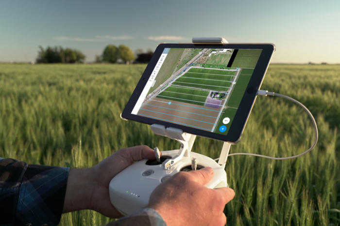
Software vendor DroneDeploy developed its latest product, called Fieldscanner, so farmers can quickly solve problems in a field before they lose crops. For the first time, it lets DroneDeploy users without an internet connection view aerial pictures while the drone is still flying. All the computing takes place on the craft and the user’s iPhone or iPad, which talk to each other over a local wireless link.
Farmers have been using drone imagery for a few years now. It’s helped to usher in more precise, data-driven agriculture, said Chad Colby, general manager of Central Illinois Ag, which sells farm implements. “We used to be farming by the field. Now we’re farming by the plant,” Colby said.
Using a drone can be quicker and less expensive than walking through a field or getting images from satellites or manned planes. Today, a drone can be launched with a smartphone app and guide itself back and forth over rows of crops, taking detailed pictures with both visible and infrared light. Software analyzes all that data together to detect problems like dead plants, poor drainage, and nitrogen deficiencies.
Armed with this information, a farmer can go into the field and check trouble spots, then add fertilizer or pest control where needed, for example. Drones also make it possible to study crops when no one can get to them, such as after severe storms.
Until now, DroneDeploy users had to send all aerial images up to the cloud or load them on a computer back at the office to use them, said Jono Millin, the company’s co-founder and chief product officer. This is a problem when someone needs to check on a field 100 miles away from the main office. A system DroneDeploy sold several years ago could send photos from the field to the cloud for instant analysis, but this required an expensive drone-based modem and an LTE connection.
With Fieldscanner, drones can transmit simple visible-light images to an iPhone or iPad in the field, in real time. There’s enough processing power in the drone and the mobile device to handle that much computing, so there’s no need for an internet connection.
These photos give a farmer enough information to immediately go out and do closer inspections. Later, the farmer can bring the data to a computer or a cloud service to extract detailed, 3D imagery.
Colby has tested Fieldscanner on farms in several states. In addition to giving regular images in real time, it can also integrate some of the deeper information after just a few minutes of processing on an iPad, he said.
One benefit of the immediate feedback is that it lets farmers move on if everything looks healthy in a field they’ve just surveyed, Colby said. Then, there’s no need to get the richer data processed or to look it over. Saving network capacity by not sending readings saying that all is well is a common use of edge computing.
Unlike DroneDeploy’s earlier, LTE-based system, Fieldscanner is pure software. It’s possible now thanks to SDKs (software development kits) from drone companies like DJI, the first manufacturer it will work with, Millin said. The product is available for all the DJI drones that DroneDeploy currently supports.
For iOS devices, users should get the best results with iPhones and iPads produced after September 2014, when the iPhone 6 was announced, he said. Fieldscanner is in beta testing and will be rolled out free to current customers over the next two weeks.